
Is the military moving you to Joint Base Pearl Harbor-Hickam (JBPHH), Hawaii? Oahu’s beaches may get most of the attention, but the island also offers spectacular mountain views, waterfalls, tropical forests, and trails for a range of skill levels.
What are the best hikes near Joint Base Pearl Harbor-Hickam? From paved coastal paths to steep ridge climbs, these Oahu hikes offer plenty of ways to see more of the island. The trails below are listed with their AllTrails difficulty ratings and are a quick drive from JBPHH. Because access and trail conditions change, check official Hawaii trail notices before heading out.
1. Koko Crater Tramway to Koko Head Lookout
Are you ready to brave this legendary climb up old railroad ties? There are over 1,000 of them, with a 900-foot elevation gain, but the view at the top is worth the effort. This old military tram turned hike is one you must do at least once during your time at JBPHH. Once you reach the top, you’ll be greeted with a panoramic view of Hanauma Bay, the shoreline, and even parts of Molokai on a clear day.
Trail distance: 1.6 miles out and back
AllTrails rating: Hard
Getting there: Short drive from Diamond Head and Waikiki. The trail begins at Koko Head District Park, where parking is available.
What else to know: This trail is quite steep with no shade. Bring water! Arrive early for cooler temperatures and a better chance of finding parking.
Is this your first time living in Hawaii? See our guide for military families moving to Hawaii for helpful information.
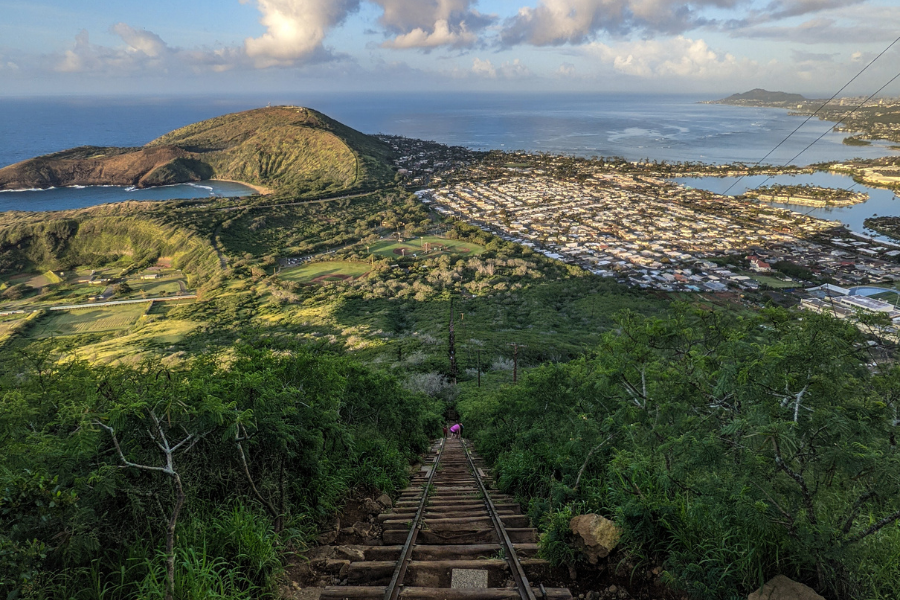 Photo by Xiaoyue Guo from Getty Images via Canva.com
2. Manoa Falls Trail
This short hike will take you to the base of the stunning Manoa Falls in Manoa Valley. Depending on recent rainfall, the trail can be muddy, but the tropical rainforest scenery, large bamboo stands, and waterfall views are gorgeous and unique. The hike is fairly short and not too strenuous.
Trail distance: 1.8 miles out and back
AllTrails rating: Moderate
Getting there: It’s a short drive from downtown Honolulu and can be accessed at the end of Manoa Road. There is a parking fee.
What else to know: You may recognize filming locations used in Jurassic Park and Lost. Check the weather forecast before you set out, as the area is prone to flash floods. The trail is usually muddy and slippery in spots, so wear proper footwear. The trail can be closed temporarily due to heavy rain or safety hazards, so check the Hawaii Trails website for updates.
3. Aiea Loop Trail
This trail is a shaded walk through the mountains with gradual climbing and an amazing view of H-3, Halawa Valley, and the coastline. Leashed dogs are allowed.
Trail distance: 4.8-mile loop
AllTrails rating: Moderate
Getting there: (from Hawaii.gov) Follow H-1 to Moanalua Highway (Route 78). Take the Aiea cutoff to the third traffic light, make a right turn at Aiea Heights Drive and follow it about three miles up to the end of the road. Continue on the one-way park road to the trailhead.
What else to know: This trail can take several hours, depending on your fitness level. There’s a B-24 bomber crash site from 1944 that may interest history buffs. No fee, and camping is available at Keaīwa Heiau State Recreation Area with an advance permit.
4. Diamond Head Summit Trail
The Diamond Head Summit Trail climbs from the crater floor to the summit of Leahi, offering panoramic views of southeastern Oahu’s coastline. Built in 1908 as part of the island’s coastal defense system, the trail includes switchbacks, steep stairs, a lighted 225-foot tunnel, and historic military bunkers.
Trail distance: 1.6 miles out and back
AllTrails rating: Moderate
Getting there: Diamond Head State Monument is located off Diamond Head Road between Makapu'u Avenue and 18th Avenue. The trail begins near the parking area on the crater floor. Entry and parking reservations are required for non-Hawaii residents. You can book parking up to 30 days in advance at the Go Hawai'i State Parks website.
What else to know: The trail gains 560 feet in 0.8 mile and becomes especially steep near the summit, with the last portion consisting largely of stairs. There is little shade, so bring water, sunscreen, and a hat. Pets aren't permitted, except for service animals.
Get MilitaryByOwner's free base guide to Joint Base Pearl Harbor-Hickam:

5. Ka'ena Point
Ka'ena Point is on the westernmost tip of Oahu and the trail follows an old railroad bed and road. It’s a shoreline hike culminating in Ka'ena Point Natural Area Reserve. The mostly level route offers wide ocean views, tide pools, lava formations, and a remote landscape that feels far removed from Honolulu’s busier areas.
The Reserve is a protected habitat for native plants, seabirds, and other wildlife. Depending on the season, hikers may see nesting Laysan albatross, Hawaiian monk seals resting near the shoreline, and migrating whales offshore. Keep a respectful distance from wildlife and remain on marked paths to help protect the sensitive habitat.
Trail distance: 5.6 miles out and back
AllTrails rating: Easy to moderate
Getting there: (from Hawaii.gov) If you use the Wai'anae route from Honolulu, take the H1 freeway west; it will eventually turn into Farrington Highway (Route 93). Farrington Highway will become a two-lane road at its northern end and terminates at Ka'ena Point State Park. If you use the Mokule'ia route, take H-2 to Kaukonahua Road (Route 803) to Farrington Highway (Route 930) past Waialua and go about one mile past Camp Erdman. The trailhead on either side of Ka'ena Point begins where the paved road ends and a rough four-wheel-drive road begins.
What else to know: Avoid damaging native flora and watch for seabird nests. Stay on paths. No dogs or other animals are allowed in the Park or Reserve.
6. Makapu'u Point Lighthouse Trail
This paved coastal trail is a great option for families, beginning hikers, and anyone looking for sweeping ocean views without a technical climb. The route rises gradually along Oahu’s windward side, with several overlooks where hikers can take in views of the surrounding cliffs and the historic red-roofed Makapu'u Lighthouse below, which was built in 1909.
During humpback whale migration season (November through May), you may spot whales breaching or surfacing offshore. Bring binoculars for a closer look, and plan for full sun since the trail offers little shade.
Trail distance: 2.5 miles out and back
AllTrails rating: Moderate
Getting there: (From AllTrails) The park and trailhead are located off of Kalanianaole Highway (Hwy. 72) at the southeasternmost point of Oahu. Turn off Kalanianaole Highway just before you bend around the island headed toward Waimanalo; park in the parking lot directly after the turnoff. The trail begins on the far side of the parking lot along the paved path.
What else to know: This is a stroller-friendly trail, and dogs are allowed on leash. Although the trail is paved, some sections may be too steep for wheelchairs and mobility equipment. On clear days, you’ll see the neighboring islands of Molokai and Lanai. This popular trail can become crowded, and the parking lot may fill early.
7. Waimea Valley Trail
Waimea Valley Trail winds through botanical gardens and Hawaiian cultural sites before reaching Waimea Falls. The gentle path includes plenty of places to stop along the way, making it a good option for families, beginning hikers, or anyone looking for a less strenuous outing on Oahu’s North Shore. The bonus is learning more about Hawaiian history and culture at one of the most archaeologically significant sites on Oahu.
Trail distance: 1.9 miles out and back
AllTrails rating: Easy
Getting there: Waimea Valley is located at 59-864 Kamehameha Highway in Haleiwa, across from Waimea Bay Beach Park. There is on-site parking.
What else to know: Admission is required, and discounted military admission is available with a valid ID. The main path is paved and accessible for most visitors, and a shuttle is available for those who can't or don't want to walk the entire distance. Nonresident parking and shuttle service require additional fees. Swimming at the waterfall is permitted when conditions are safe and lifeguards are on duty, so check the daily swimming status when you arrive. Make a day of it and consider staying for the evening luau.
8. Kuli'ou'ou Ridge Trail
Nice trail through pines, culminating in a stair climb. View wildflowers along the way, then at the top of the ridge, you’ll be greeted with a sweeping landscape. Rated moderate, but it can be challenging for beginners.
Trail distance: 4.1 miles out and back
AllTrails rating: Hard
Getting there: (From AllTrails) Directions from Honolulu: From Kalanianaole Highway heading east, take a left on Kuliouou Street toward the back of the valley. Follow the curve to the left, and take a right on Kuliouou Road. Proceed mauka (mountain) on this road, turn right on Kalaau Place, continuing to the cul-de-sac at the end of the street. Park at the end of the cul-de-sac, and proceed on foot past the cable gate on the access road. The trail begins on the right of the access road at the hunter/hiker check in station.
What else to know: No bathroom facilities or dedicated parking. There are two picnic areas. The trail is steep in places and can be slippery when wet.We’ve barely scratched the surface of Oahu’s hiking options. Other popular trails include the Lanikai Pillbox Trail, additional coastal walks, and challenging ridge routes like Olomana Trail (the Three Peaks) for experienced climbers. Always research current access, parking restrictions, weather conditions, and trail difficulty before setting out.
Wondering what it's like living near Joint Base Pearl Harbor-Hickam? MilitaryByOwner’s free JBPHH base guide includes information about neighborhoods, commuting, schools, and local resources. You can also search Joint Base Pearl Harbor-Hickam housing, Ewa Beach rentals, apartments for rent in Honolulu, and more on our home page.